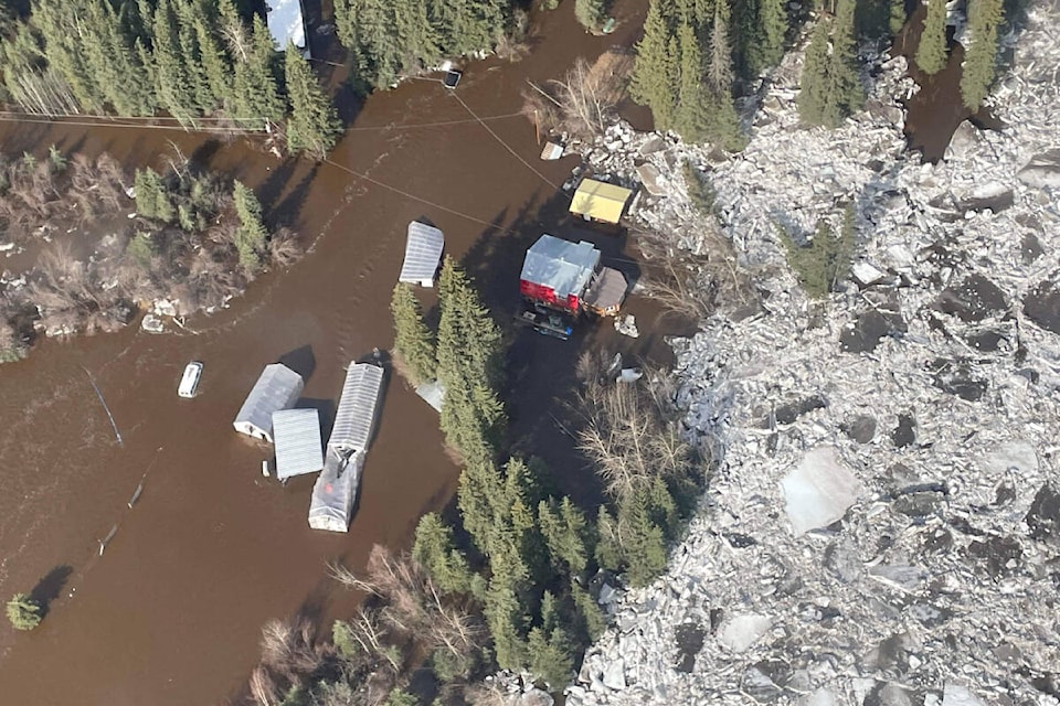
More than 30 applications were filed to the Yukon’s Klondike Valley flood recovery funding program for more than $1.5 million in claims, according to a Yukon government press release.
The program provides money for housing, small businesses and agriculture affected by severe flooding in spring 2023 in the Klondike Valley area, near Dawson City, per the release issued on Jan. 17. More than 80 evacuees registered with the Yukon government’s emergency support services due to flooding, according to territorial officials during the flood response.
Five forms were submitted under the program’s agriculture stream for an estimated total of $750,000 in claims.
Twenty-two households will be getting over $700,000 in recovery funding from the Yukon Housing Corporation.
Five applications were received under the small business stream.
An after-action review will be conducted for the Yukon government by contractor Stantec.
According to Julia Duchesne, who works in Yukon government communications for protective services, formal after-action reviews occur after major incident responses like the wildfires near Mayo and Old Crow in 2023. During a Jan. 23 interview, she said small callouts will typically happen after smaller events to consider how the response went and how protocols might be tweaked going forward.
As part of the after-action review for the Klondike Valley, flood-affected residents can express their experiences and concerns with the intention of making future flood responses better.
An online survey will be running until Feb. 16.
A public meeting, which could be attended in person or virtually, was held on Jan. 23 in Dawson City.
Duchesne noted that the two local governments — City of Dawson and Tr’ondëk Hwëch’in First Nation — have their own emergency plans. The territorial government’s Emergency Measures Organization has been helping the local governments to update those plans. Last spring, emergency planning took place with both First Nation and municipal governments at the same time.
Emergency plans vary by community, Duchesne said.
“It’s just making sure that everybody is aware of roles and responsibilities during an emergency and what steps will be taken to, you know, keep people safe [and] to help keep critical infrastructure safe,” she said.
For example, Duchesne noted the Klondike Valley doesn’t have a local government since it’s located outside the Dawson City limits, so local responders from the Klondike Valley Fire Department were looped in.
She said updating the emergency plans will incorporate lessons learned from flooding in the Klondike Valley in 2023.
“That’s, you know, a real test of an emergency plan, and making sure that those lessons are enshrined in the plan going forward,” she said.
Per Duchesne, the planning will look at everything from what it looks like when an incident management team is pulling from lots of different governments — who reports to who and how do they stay coordinated. Communications planning, such as rolling out daily radio updates sooner than a few days into a flooding emergency like last year, will also be included.
The Emergency Measures Organization will likely head back to the Klondike Valley area in February to continue the emergency planning work, Duchesne said.
Flood mapping for Dawson City and the Klondike Valley is in the planning stage, according to the Yukon government’s flood atlas website. Those flood hazard maps are expected to be completed in late 2025.
The Yukon government’s goal is to produce maps for 14 flood-prone communities: Klondike Valley, Dawson City, Teslin, Old Crow, Ross River, Mayo, Upper Liard, Pelly Crossing, Whitehorse, Carmacks and Southern Lakes (including Carcross, Tagish, Marsh Lake, and Lake Laberge).
The first draft maps for Southern Lakes and Carmacks are out for public scrutiny until Feb. 9.
Contact Dana Hatherly at dana.hatherly@yukon-news.com