Michael Gates
History Hunter
I watched the news coverage on TV as the most recent eclipse cast a long shadow across North America, from Mazatlan in Mexico in the South to Newfoundland in the Northeast. Millions travelled to points along the path of the eclipse to see it in person.
People viewed it with awe and wonder as one of nature’s marvellous events.
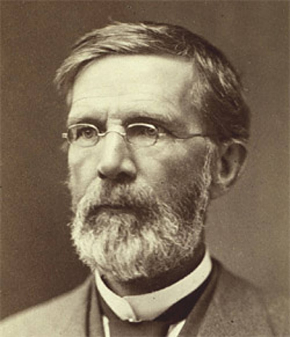
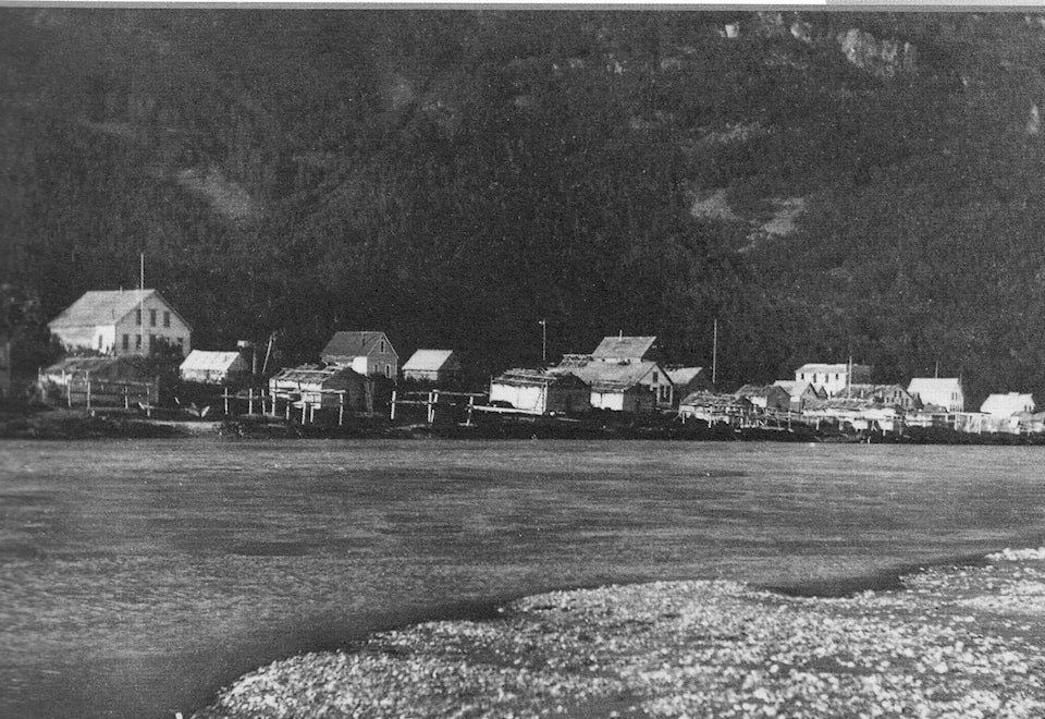
An eclipse passed over the Yukon 155 years ago, and it, too, was viewed with fascination, with a little terror mixed in. American geographer George Davidson had two years earlier (1867) calculated that the eclipse that would cross the continent two years hence would pass directly over the Chilkat Tlingit village of Klukwan, on the Chilkat River, not far from Haines, Alaska. He was determined to witness the event at Klukwan.
Scanning various articles on the Internet, I determined that the record should be set straight. One such article stated that Davidson and his party were spotted by the Chilkats near Klukwan, and “the suspicious locals became angry and threatening.”
The article from the Ancient Pages website went on to state that the lives of the Davidson party were saved by the eclipse.”
In fact, it was the contrary.
General Jefferson C. Davis, on behalf of Davidson, invited the Chilkat Chief, Kohklux, who presided over Klukwan, to visit Sitka, meet Davidson and make arrangements for Davidson’s party to visit Klukwan. Before Davidson arrived for the meeting, Kohklux and several other Chilkat people ended up in jail over some minor infraction.
Under tense circumstances (some of the Kohklux delegation were shot trying to escape custody), Davidson brokered a deal that freed Kohklux and his people from jail in exchange for access to their village to view the eclipse. Kohklux kept his end of the deal.
According to Davidson, “For the release of his people … he (Kohklux) promised us assistance and protection wherever we chose a station; and he fulfilled in spirit and letter every promise and our every wish was attended to.”
The weather on the day was cloudy, but according to newspaper accounts, “…breaks in the clouds enabled the different phases (of the eclipse) to be watched and the beginning of totality was accurately noted. Instantly after the obscuration, rose colors of flames were visible to the unassisted eye…The corona was visible over part of the limb only.”
Then, the clouds rolled in and obscured the remainder of the event.
According to a news report, the citizens of Klukwan were “fearfully alarmed and hid in their houses or took to the bush.”
The phenomenon impressed Kohklux, who saw Davidson as the chief magician behind this remarkable event. Davidson made a sketch that illustrated how the eclipse occurred, and that, along with his apparent ability to make the sun disappear, impressed the great chief.
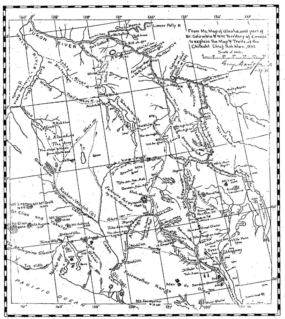
In exchange, Kohklux proceeded to draw a map showing the route followed by him and his father’s party when they went to Fort Selkirk in 1852 and destroyed the post that the Hudson’s Bay Company (HBC) had established there.
The Chilkat had grown in stature and wealth because of the trade network they had established with the First Nations of the interior, and it is safe to say that both sides of the trade relationship benefitted from the exchange of goods. But they guarded access to the interior to maintain control of the trade.
The HBC post at the confluence of the Pelly and Yukon Rivers (halfway between Whitehorse and Dawson City) posed a threat to that monopoly. With the fort destroyed, the monopoly continued for nearly another half century.
The Chilkat chief decided that he needed a larger sheet of paper if he was going to chart the journey taken 17 years before. Davidson gave him a large topographic map, and on the back of it, Kohklux, with the assistance of two wives, collaborated on the drawing of a second map.
It took them two or three days to complete the much more ambitious work.
The map he created was not in the familiar form used by mapmakers of the day, and the pencil and paper was a medium that he had never used before. The distances on the map reflected the time required to get from one place to another.
Features, such as lakes, rivers, mountains, and important places along the route, were noted.
Davidson talked to Kohklux about place names, rendering them phonetically in notations he added to the map. According to Davidson, “…under his direction we applied the names to all important positions and objects, and they number over 100.”
The esteemed geographer reported that the chief was impressed by his ability to pronounce the Tlingit names noted on the map.
The map shows a route that went from Klukwan over the mountains, down Kusawa Lake and the Takhini River, to the Yukon and thence over Lake Laberge and down the Yukon River to Fort Selkirk.
On the return trip upriver after the attack, the party veered off the Yukon River at present-day Carmacks and followed a route up the Nordenskjold River, past Hutshi Lakes, along the Dezadeash River and the shores of Dezadeash and Klukshu Lakes, then over the summit following the same route that the Haines Road follows today.
In total, the round trip took 60 days to complete, the latter part of the return on snowshoes.
The details on the map revealed physical features of the interior that hitherto had been unknown to Europeans.
The places of significance were noted in the language of the coastal tribe that used the trail for their trading business.
The contents of the map were not published in a much-modified version by Davidson until 1901, by which time, much more was known about the region.
A portion of the route into the interior over the trade trail became known by the Americanized name, the Dalton Trail.
Historian and former Territorial Archivist Linda Johnson portrays Kohklux as a brilliant, highly respected leader and diplomat for the Tlingit people of the Lynn Canal. The maps he drew were a reciprocal gift he exchanged with Davidson, the magician who made the sun disappear.
Eighty years later, the location of the two maps created by Kohklux was lost. Linda Johnson recognized their importance and resolved to hunt them down.
She contacted libraries and archives located across the continent, without success, but a lead she got from the University of Alaska in Fairbanks led her to the Bancroft Library in Berkeley, California. In 1984, thanks to her persistent effort, the two valuable documents were located and their importance recognized.
Three years later, the famous map made a visit to the Yukon during a Yukon Historical and Museums Association (YHMA) conference. In 1995, YHMA released a book about the Kohklux map, complete with a copy of the map in a pocket on the back cover.
More recently, in October 2019, another YHMA conference with the Kohklux map as its theme was held at the Kwanlin Dün Cultural Centre. The first of the two maps created by Kohklux was on display, along with another nineteenth century creation, the Kandik map. Unfortunately, the larger, more detailed of the two Kohklux maps was deemed too fragile to travel to the Yukon, but a replica was put on display during the conference.
Thanks to an eclipse, a prominent geographer and a highly respected Chilkat leader, we can enjoy and learn from two of the most important documents in Yukon history.
Michael Gates was the Yukon’s first Story Laureate from 2020 to 2023. His latest book, “Hollywood in the Klondike,” is now available in Whitehorse stores. You can contact him at msgates@northwestel.net.
Editor’s Note: The discussion of the Oct. 2019 YHMA conference in an earlier version of this column contained some innacurate and incomplete information. The column has been amended at the author’s request to more accurately represent the facts.