Last week, I attended a commemorative ceremony at Soldier’s Summit, beside Kluane Lake. Nearly 200 Yukoners, dignitaries and highway visitors attended the event on June 29th that recognized the 75th anniversary of the construction of the Alaska Highway.
The original ribbon-cutting ceremony took place high above the current highway on a promontory overlooking Kluane Lake on November 20, 1942, and I was grateful that this event was held in the summer. Everybody at the original ceremony back in 1942 was wearing their long johns, and rubbing their hands together to keep warm in the sub-zero conditions.
At last week’s event, I was tasked with greeting visitors and answering their questions about the history of the highway. It brought back a flood of memories, and affirmed that even wilderness areas like this are filled with human history.
When I arrived at this place 46 years ago, the large truss-style bridge that spanned the Slims River was obscured by the dust that was blowing off the flats to the south. The waters of Kluane Lake lapped the edge of the road. Today, silt has been deposited in the lake to the extent that a rocky island opposite soldier’s Summit has been captured by the delta. During the afternoon, I observed someone wheeling out to the island on an all-terrain vehicle.
Several hundred years ago, Kluane Lake drained south through the Slims River and down the Kaskawulsh River to the Pacific Ocean. The Kaskawulsh glacier advanced during the Little Ice Age, forcing the water to find a new place to drain at the north end of the lake. The recent news, that the retreat of the Kaskawulsh Glacier has caused the Slims River to once again drain into the Pacific Ocean, is another example of a landscape that has been changing and reforming for thousands of years.
During my first visit to the region in 1971, I climbed to the top of Sheep Mountain (Tachäl Dhäl in the Southern Tutchone language). The view from the top was spectacular. In every direction I could see a landscape that would later speak to me of the history of the region.
In the far distance was the Kaskawulsh glacier. A quarter century ago, scientists found an artifact made of grizzly bear skin on a nunatak piercing the glacier in a place with nothing but ice and rock in every direction. Radio-carbon dating determined the object to be 1,000 years old.
Looking across to Vulcan Mountain, I could see an alluvial fan which I later visited, that was filled with brush huts, caches and log cabins. These structures attest to the heavy use of the area before the Alaska Highway was built.
The highway snakes along a route blasted out of the rocky shore. Near the Tachäl Dhäl visitor centre, a little cabin nestled along the shore, now isolated on an abandoned stretch of the old highway, was occupied by Alex Fisher until he died in 1941.
In 1914, Alex, and his brother John Bruce Fisher recovered $7,000 in gold from nearby Sheep Creek. Two years later, they enlisted in the Canadian Expeditionary Force and were shipped overseas during the First World War. Alex returned to Kluane, but John Bruce is buried in a cemetery in England.
Edward Glave and Jack Dalton were the first white men to penetrate this country. In 1891, they explored Kluane, looking for copper deposits that were rumoured to exist nearby. They encountered several first nation families during their travels, none of whom would share the secret of the elusive copper.
The two men borrowed a dugout canoe they found cached near Kluane Lake and went exploring along the shore. A sudden squall capsized their little craft, and they almost perished in the icy waters.
Across the Lake from Tachäl Dhäl is the cluster of abandoned buildings that was once known as Kluane, or Silver City. When gold was discovered on Bullion Creek, in the Slims River valley, hundreds (including the legendary Nellie Cashman) stampeded to the area. Silver City was established at the end of a hastily built wagon as the supply point for the prospectors and miners.
The gold rush quickly petered out, but a few die-hard newcomers remained in the district. One of them was Morley Bones, who homesteaded at Silver City and established one of the largest fur ranches in the Yukon. When I first visited the site in 1971, the buildings were still intact. Today, they are collapsed and overgrown by the forest, and soon will be gone.
At one time, 40 or 50 people clustered around this settlement. For a short time, there was a Mountie stationed here, as well as a post office and a mining recorder (mining recorder Percy Reid eventually became the Yukon’s gold commissioner). By 1924, the community was virtually abandoned.
As soon as the Alaska Highway was constructed, the Canadian government established a game sanctuary in which hunting was forbidden, and earmarked the land enclosed by the Haines road and Alaska Highway as a future national park. Even the first nation people of Kluane were denied access to the land where they had hunted for generations.
The original highway at Soldier’s Summit was more like a goat trail up and over the steep rock wall that faced the lake at this point. During last week’s ceremony, I was asked when the current road was first blasted out along the edge of Kluane Lake.
One resident of the area told me that this work did not happen until the 1950s, then another sent me a photograph dated 1948 clearly showing a large shovel excavating rocks from the lakeside cut. I suspect that research will show that the shoreline cut was made shortly after the road was built.
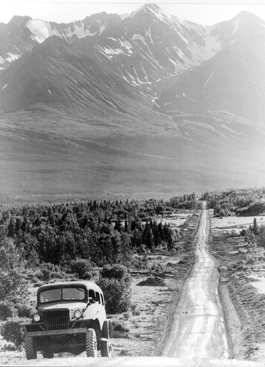
An old photograph I had selected for display at the ceremony showed the highway approaching the front ranges of the St. Elias Mountains. I had always assumed that it was a particular stretch of road leading into Haines Junction, but I took a comparison photograph on my way back to Whitehorse after the ceremony, and they didn’t match. Gord Allison of Haines Junction has since provided me with an answer to where the picture original photograph was taken.
The visit to Kluane rekindled old memories, dredged up knowledge I hadn’t drawn upon in years, and raised new questions to be answered.
Michael Gates is a Yukon historian and sometimes adventurer based in Whitehorse. His new book, From the Klondike to Berlin, is now available in stores everywhere