How We Walk with the Land and the Water is an undertaking by three Yukon First Nations that uses modern technology to support traditional local knowledge of the land and wildlife by bringing it into a more recognizable form for those in a western scientific setting.
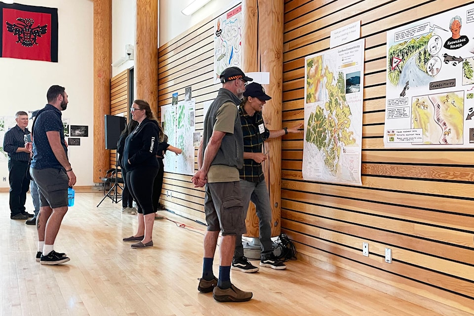
For two days, July 26 and 27, open houses were held in Whitehorse and Carcross. Citizens and community people were invited to view and comment on the draft maps and visuals that had been created during the pandemic by the three nations — the Ta’an Kwäch’än Council, Kwanlin Dün First Nation and the Carcross/Tagish First Nation.
The maps encompass the traditional territories of all three First Nations, and Elders from all three had participated in their creation. This was the first time the draft maps had been on display to be critiqued. The maps were arranged by season, and people moved around and were invited to add information, asked what was missing, and queried as to how the maps matched their experience. Everything was draft, and mid-process.
The project uses GIS technologies to layer what Indigenous people know about the land, the water and the animals who live with it. Colleen James, a cultural advisor and water ambassador, calls them all her relations. She says the process is to help make a plan that teaches us “how to use this land without sacrificing our relatives in it.”
Both a project and a process
James is from the Daklaweidi clan with Carcross/Tagish First Nation. She was an original negotiator of the land claims settlement for her nation. She was never comfortable with the separation in the Umbrella Final Agreement (UFA) with one chapter for managing land and another chapter for managing water.
In the 29 years following the signatures on the UFA, James and others have watched the slow progress of western planners on land use planning obligations.
She said they watched the development of the North Yukon plan, witnessed the legal wrangling around the Peel plan, and realized that Indigenous perspectives were not understood, nor were they incorporated into the land planning processes.
Plans were being developed without the full understanding of the relationships between land, waters and animals. The land needed to be viewed through the lens of the elders who walked the land carrying the knowledge of generations before them.
Leaders decided they wanted to prepare for the planning process in a way that made sense to them.
The challenge was to make traditional knowledge accessible; to make it transferrable; and to be able to store it. Then it could be interpreted and the knowledge could be used for planning and informed decision-making.
Enter technological solutions
“We made use of satellite imagery interpreted for vegetation land cover — the pine forest, the aspen, the rock leaves, high alpine. Then we created about 40 to 50 habitat classes,” said John Meikle, a planner and consultant who has been on the project since the beginning in 2017. Meikle has worked in the Yukon for decades.“I had pictures of each one of those [habitat environments]. Then we met with Elders from Ta’an Kwäch’än, Kwanlin Dün, and here at Spirit Lake with Carcross Tagish.”
Fortunately, these exchanges took place before the pandemic shut other planned gatherings down.

These early conversations helped connect different species to the various scientifically named ecological zones, and by asking Elders how the animals moved to different habitats in different seasons, patterns emerged. The technical team also loaded animal tracking data from moose and caribou collars into the data set.
How we Walk mines other sources of available information as well — historical recordings, place names projects, caribou recovery project interviews, anthropologists and scientists — all in a quest to put all the information in one place. Then it could be digitized, sorted, attributed and put into the map layers in the GIS system.
This means that all the information from different sources in the data set are attached to “place” in the GIS layers. For instance, an interview that discloses the presence of a different type of white fish in a particular location would be connected on a map to that body of water.
Another example Meikle provided is that caribou only sleep in certain areas around Tagish Lake in the winter. In the fall they are on the move, using traditional corridors that are more and more being blocked by settlements and made dangerous by highway traffic.
“We heard a lot from Carcross/Tagish Elders about the winter wood-cutting trails being converted to dog-mushing trails, and then how that network impacted caribou,” he said.
“So [if] you look at it from the air, you don’t see that impact. But caribou are really disturbance-sensitive. They only have so much energy (fat reserves) in the winter to take to running, to take flight. If they are at risk — they’re not producing a healthy calf.”
Meikle continued explaining how many of the valley spaces without trees are now the place of hay fields, agricultural leases and horses. These were once the places where moose could be easily hunted.
Jen Herkes, who also conducted some of the interviews, said it was not unusual to hear from Elders that they had been told as children to stay away from certain places, either all the time, or just at certain times of the year.
Informed planning reflects cultural values
Once the information is verified by the communities, then the maps will be overlaid and it will be possible to start highlighting areas that have values that are especially precious to different species, the Elders and the community.
Then informed planning can occur.

James animates her relations. Her enthusiasm as water ambassador is palpable. She carries with her a wallet that contains ten tiny vials of water from different lakes and streams, so the waters can hear the words being spoken around her. In the same pouch, next to the water vials, is a computer stick that carries some the information that has been gathered throughout the How We Walk with the Land and the Water process.
Contact Lawrie Crawford at lawrie.crawford@yukon-news.com