The future may be catching up with North Yukon, a region with one of the lowest levels of economic activity in the territory.
But first, the North Yukon Planning Commission is attempting to determine how to balance economic prosperity with environmental and wildlife conservation in the area.
The commission is drafting a regional land use plan and mapping the remote territory to discover where development — like oil and gas drilling — would have the least harmful effect on landscape, people and animals.
The commission will determine how to boost the region’s slow tourism and culture industry without compromising sensitive areas.
The initiative “is intended to balance the different values in terms of economic potential, development potential and wildlife conservation values in the region,” said land planner John Ryder, who is working with the commission.
The North Yukon region is a 57,000-square-kilometre chunk of land in the heart of Vuntut Gwitchin traditional territory bordered by Alaska to the west and the Northwest Territories on the east.
The North Yukon Planning Commission is narrowing its focus to a 37,000-square-kilometre swath — excluding the Fishing Branch Ni’iinlii’njik Park, Vuntut National Park, and Old Crow Flats, which will have its own land use plan.
The region understudy is home to three of the territory’s eight areas with “very high” potential for oil and gas extraction — Eagle Plain, the Kandik Basin and Old Crow Basin.
Six trillion cubic feet of gas and 435 million barrels of oil are locked in Eagle Plains, according to government statistics.
Oil and gas extraction is the quickest way to bring cash into the region, but it also has the highest potential for landscape-level change, said senior planner Shawn Francis.
And planners tread softly on this area because it contains many unique environmental features and wildlife habitats.
It’s part of Beringia, an ancient unglaciated area with unique landforms, plants and fossils of extinct ice age animals such as mammoth and steppe bison.
It contains the Blue Fish Caves, one of North America’s oldest recorded sites of human occupation, and Old Crow Flats, Yukon’s largest wetland area, one important for migratory birds.
And it serves as the wintering grounds for the Porcupine caribou herd.
The Dempster Highway, the only all-season road in Canada that crosses the Artic Circle, runs through the region.
The sites of the trading posts and gathering places Rampart and LaPierre House, have major heritage value.
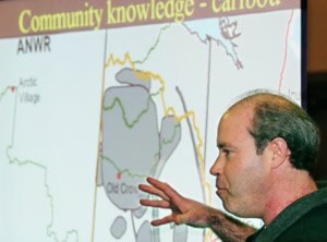
The commission mapped out sensitive areas by combining scientific information with the traditional knowledge gathered from interviews with Gwich’in elders.
Researchers followed three species singled out by Old Crow residents — moose, marten and caribou — to see which areas are important to each population.
They found that marten stick below the tree line and are resilient to change, while moose migrate widely through the area and those routes will only expand as the region’s climate warms.
Caribou use the entire region, but the area around Eagle Plains has been used less in recent times, said Ryder.
The commission has hosted a series of public meetings in Old Crow and Whitehorse and will draft a land use plan, due for release in July.
Both the Vuntut Gwitchin and the territory must approve the plan, which then will be revised every three to five years.
The Tr’ondek Hwech’in First Nation, Tetlit Gwich’in, Na-cho Nyak Dun and Inuvialuit also have interests in the region.