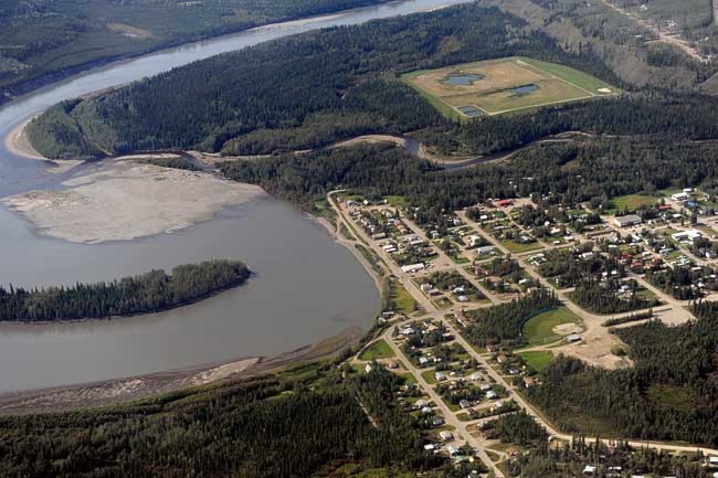
Mayo residents know when the Stewart River runs high, it’s time to flip on their sump pumps to prevent their basements from flooding.
But that’s sometimes not enough, when you live, as they do, on a floodplain at the confluence of the Stewart and Mayo rivers. The village flooded in December.
Most blame, in part, what’s misleadingly called a dike.
Dikes keep water out. But water flows beneath this berm, which was once composed of organic material, such as trees, that have since rotted away, leaving holes that let the Mayo River’s waters through.
The berm is now being studied for repair, but the Yukon government could be doing more to help protect village residents.
At present, no agency is monitoring the movement of Mayo’s subsurface water. If it were monitored, this information could help get a jump on future floods.
In comparison, Whitehorse has long monitored the levels of wells. Similar work in Mayo – which could help anticipate future floods – has been slapdash.
“There is no data to try to quantify what’s going on,” said Kristen Kennedy with the Yukon Geological Survey. She’s an author of a report, released in March, that sizes-up the threats climate change poses to Mayo.
One of the report’s recommendations is that the territory begin a groundwater monitoring program for the village.
The report also recommends further study of permafrost. Much of Mayo sits atop the frozen ground. As the world warms over the next few decades, this could make Mayo’s periodic flooding worst. Or better. Without further study, it’s hard to say.
It’s possible that a sheet of permafrost serves as a floor to underground water, and that as this ice melts, the water table will sink. Or the ice could prevent water from rising. Nobody knows.
“Until you drill, you don’t know for sure,” said Kennedy.
Much of Mayo’s permafrost is already close to melting, and modest projections have temperatures in Mayo rising by 1.7 degrees Celsius by 2030 and 2.1 degrees Celsius by 2050. The medium-high forecast calls for increases of 1.5 degrees Celsius by 2030 and 3.2 degrees Celsius by 2050.
“We’re confident the permafrost will melt,” said Kennedy. “It’s on its way out.”
For evidence, Kennedy needed look no further than the state of the recently built annex used by Yukon College in Mayo. As the ground beneath the building shifts, cracks have appeared on inside and outside walls.
Kennedy spent five weeks wandering Mayo with a backpack and shovel, mapping the area’s geology. To find permafrost, she’d zap the ground with a car battery and watch how the electricity dissipates. Ice does not conduct electricity well.
She also used a small drill, powered with a chainsaw motor, to take core samples.
Much of the resulting report is technical, but it includes an easy-to-read “stoplight map,” so-called because high-risk areas are marked red, medium-risk yellow and low-risk green. It should be useful to planners and developers with the municipality, territorial government and First Nation of Na-cho Nyak Dun.
An area flagged as red won’t necessarily sink. But anyone planning to build on a risk-prone area would be wise to hire a geotechnical engineer to poke around the area first, said Kennedy.
The First Nation built its new headquarters on a hill for good reason. Some older homes in its possession were abandoned after being overcome by black mould, in part because of the tendency for basements to flood.
Part of the Mayo airport’s gravel runway is also slowly sinking. Kennedy suggested demolishing one end and extending the far side. Officials “thought it was hysterical,” she said.
A big gravel patch sits beside the runway, making it far cheaper to repair the runway each year than tear it up and move it.
As Mayo’s permafrost melts, it will likely cause water mains to buckle and break. The subsequent release of water may melt more permafrost, speeding up the process, said Kennedy.
The municipality may want to consider installing bigger culverts around the village, to prepare for the onslaught of water.
Many Mayo residents blame Yukon Energy for the winter flooding. The utility is expanding its nearby hydroelectric facilities.
But construction work was done out of the water at the time of the flooding, said spokesperson Janet Patterson.
Mayo’s biggest flood struck in 1936, when the Stewart River rose 4.8 metres above the usual watermark. The waters washed away houses and destroyed the church while residents fled to high ground across the river.
If there’s a bright spot in the report, it’s this: Mayo may be sinking, but there are few reasons to worry about it being hit by landslides.
And a similar study found Pelly Crossing to be at little risk from climate change. The community is perched up high enough that it’s unlikely to be ever at risk from floods.
The report was prepared by the Northern Climate Exchange, a research arm of Yukon College, with help from the universities of Alberta and Ottawa. The study cost $250,000 and was paid for by Indian and Northern Affairs.
Contact John Thompson at
johnt@yukon-news.com.