A flood alert for Bennett Lake, Marsh Lake, and Tagish Lake was released yesterday. For many in the area, it was no surprise. Anyone with a shovel this past winter knew that much more snow had fallen than usual.
The Carcross/Tagish First Nation (C/TFN) had been asking for support in anticipation of record flood levels all spring. In late May and early June, Southern Lakes locals were told that record-high water levels, last seen in 2007, weren’t expected this year — even with record snowfall.
Those expectations relied on cooler than normal weather conditions. The recent bout of hot weather sent all models into a tailspin. Now the Yukon government’s modelling has changed, and it is being revised daily. The release states that the three lakes rose more than 10 centimetres in the last 24 hours. They believe that many parts of the southern lakes region may reach 2007 levels as soon as this weekend, eventually exceeding those levels by 15 to 20 centimetres and staying high throughout the summer.
| Ninety truckloads of dirt were hauled into Carcross on June 29 in preparation for flooding. (Lawrie Crawford/Yukon News) |
Words like unprecedented, rapid, and unpredictable were used by officials from Community Service’s Protective Services Branch, Water Resources and Yukon Energy Corporation at a June 29 meeting with Marsh Lake residents. For many residents, flooding is imminent.
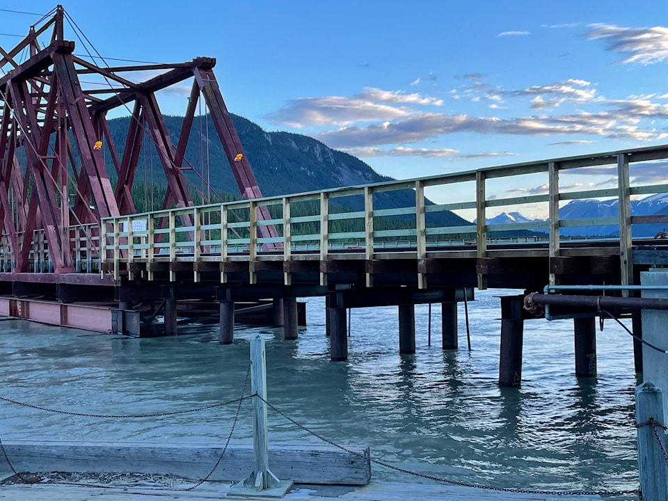
The Yukon government is still far ahead of what happened in 2007. On June 28 they met with C/TFN in Carcross and moved quickly. The south side of the Naataase Héen River, between Carcross’ three bridges (a footbridge, a rail bridge and a new highway bridge), was deemed in need of protection.
The next day, 90 truckloads of dirt were hauled in, dumped, then carefully placed by a large excavator. Plastic had been laid flat on the road, the dirt was piled on half of the plastic, then the remaining plastic was wrapped around and over, and anchored with rocks to make a long snake-like barrier along the road edge.
Elder Walter Huebschwerlen looked on. He’s lived on the river since 1989 and recalled 2007 clearly. Then, the water lay a few inches deep on the road in front of his house. He is glad to see the berm go up, since he expects this year to be much worse, as “it’s just the end of June.”
Frank James, C/TFN’s director of lands and natural resources, agrees.
| Plastic was laid on roads and anchored in Carcross on June 29. (Lawrie Crawford/Yukon News) |
“We know that the highest levels are in August. Right now, we are beyond some of the August levels,” James said. “Protecting residences is the priority.”
The government’s incident commander agreed. “Primary residences are most important. We are triaging our response,” they said. Heritage buildings and seasonal residences are not a priority. The water is rising too quickly.
The river is pushing up against the low cross-beam on the rail bridge. Under the new highway bridge, the force of the current is threatening the integrity of the underpass on Waterfront Drive. Yukon government employees looked over the bank and said, “We’re watching.”
How much worse? How high?
Yukon Energy stressed the difficulty predicting how much water will flow into the lake system from glacial melt, snowpack melt and rainfall. Right now, good data for predictive modelling is not available.
Unlike 2007, an incident command system is in place, and officials have a better sense of what to expect and also, a better sense of what they do not know.
Given all this, and the rapidly changing situation, six flood experts are flying into the Yukon on Wednesday. When it comes to protection against disaster, all hands and minds are needed.
Contact Lawrie Crawford at lawrie.crawford@yukon-news.com