Marina McCready | Special to the News
We woke at anchor off Gjoa Haven Sept. 11 — a community of about 1,400 located on the southeast side of King William Island.
The community was named by Roald Amundsen when his ship — the Gjoa —spent two winters (1903 and 1904) in the sheltered harbour blocked in by ice before he was able to complete his journey becoming the first through Northwest Passage. It was here he learned from the Netsilik Inuit how to dress in animal skins, travel by dog team and survive in an Arctic environment. This knowledge set him apart from other explorers of the time and was crucial to his success in his later journeys when he was first to the South Pole in 1911 and first to fly to the North Pole in 1926.
Canadians pronounce the community name as “Joe Haven” but a Danish passenger on our ship told me Amundsen’s ship is pronounced “Goya” in Norwegian. He thought it quite hysterical that Canadians have turned Goya into Joe. I had no defense to make.
Once ashore we were divided into groups and sent off with guides from the community. I didn’t stick with my group for long as my main objective was to see an Amundsen monument at the top of a hill above the harbour. It was a cool, beautiful sunny day as I strolled along the beach and up the hill. I caught site of a few snow buntings and horned larks flitting between snow patches. The Amundsen monument commands a beautiful view of the harbour and I could instantly see why Amundsen chose this spot to overwinter as it is very protected.
Later on, the community hosted our ship with drumming, dancing and throat singing followed up with a taste of country food (char and caribou soup). My last stop was the Nattilik Heritage Centre. The outside of the building is impressively adorned with stylized paintings of muskoxen and huge Inuit snow goggles framing the windows. The centre has a nicely displayed collection of archaeological and historic artifacts including a very convincing replica of the ship’s bell recovered from the Erebus in 2015. The actual bell is now in England. A portion of the centre is a gift shop offering an extensive variety of locally produced Inuit art, carvings, clothing, etc.
The next day we travelled slowly skirting pack ice along the western shore of Boothia Peninsula in Larsen Sound. At times the ship would change direction to avoid hitting larger pieces of ice and at other times would bump smaller chunks with its reinforced hull sending them spinning away. It was fascinating watching the incredible sizes, shapes and colours of the ice chunks going by. There were also a number of seals and small flocks of eider and long tailed ducks flying around the ice while glaucous gulls and northern fulmars soared around the ship.
Adventure Canada had experts on deck to help us identify the wildlife. I was fascinated by the fulmars which look like small gulls with a stiff-winged flight. They have an extra tube on the top of their beaks through which they violently expel excess salt from their marine diet.
Late afternoon we passed the last of the ice and dropped anchor at the entrance to Franklin Strait where we went out in zodiacs to visit Coningham Bay on Boothia Peninsula. The bay is known for being a good place to spot wildlife and it did not disappoint as we saw a female polar bear with a cub, two lone polar bears as well as a large pod of Beluga whales.
Later that night we passed the top end of Boothia Peninsula, which is the northernmost point of the North American mainland.
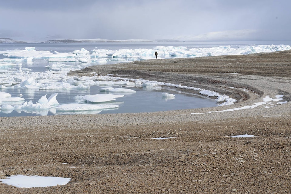
Today was the first opportunity we had to explore the High Arctic environment on foot in Aston Bay on the northwest coast of Somerset Island
As would become the norm, bear guards and crew went ashore ahead of the passengers. The bear guards would make sure a large area was free of polar bears before taking up watch positions at high points around the perimeter of the area where we would be walking. The staff would position themselves at various locations where they found something interesting and we could go to them to learn about plants or archaeological sites or whatever they found in a particular place.
I was fascinated by the raised beaches paralleling the curve of the shoreline. These are step-like terraces that make lovely flat walking surfaces for human and beast alike. They are caused by the earth rebounding (isostatic rebound) when the weight of a glacier melts away. In this case it was the melt of the Laurentide Ice Sheet that covered most of North America during the last ice age.
There were other things to see as well, like an archaeological site, an ancient food cache, polar bear tracks and skeletal remains of a few small whales. This was the first place I was introduced to the amazing Arctic willow which is a very short creeping willow that hugs the ground poking up barely a centimetre or two.
Marina McCready is a Whitehorse based freelance writer and photographer. This piece is second in a five-part series.