Two things impressed me about my recent trip to Watson Lake. The first was made clear when my wife Kathy and I stopped at a pull-off at the continental divide, located between Teslin and Watson Lake.
The water behind us drains away to the northwest via the Yukon River, to the Bering Sea. The water ahead of us flows east into the Liard River, a large but rapid-ridden tributary that joins the Mackenzie River on its way to the Arctic Ocean.
The second was that Watson Lake did not have its origin in the Klondike Gold Rush, as have so many Yukon communities. Instead, it had its genesis in the second invasion of the Yukon during the Second World War.
The antecedents of the present-day Kaska First Nation occupied the land for millennia before Europeans arrived, living a productive lifestyle by exploiting various resources available to them across the landscape. One of their encampments, not far from Watson Lake, on the Liard River, some distance below its confluence with the Frances River, was an important place for meeting the Tahltan people from the west for the purpose of trade.
The Hudson’s Bay Company also took an interest in the fur trade in this district. In 1831 and 1834, John McLeod was sent to the region to delineate the course of the Liard and Dease Rivers. In 1837, Robert Campbell established a trading post at Dease Lake, but under instructions from the HBC, he pushed up the Liard River to Frances Lake in 1840, passing the future site of the town of Watson Lake without making note of the passage.
Campbell proceeded to Frances Lake and then on to Finlayson Lake, from which point he became the first known European to cross into the Yukon watershed from the east. He established posts at Frances Lake (1842), Pelly Banks (1846) and Fort Selkirk (1848), the latter site being located at the confluence of the Pelly with the Yukon (Campbell called it the Lewes River).
Fort Selkirk was destroyed in 1852 by the Chilkat Tlingit from Klukwan who didn’t like the intrusion of competitors from the HBC, and the big company’s trading interest in this region was withdrawn for the remainder of the century.
Gold was discovered in the Stikine region in 1861 and in the Cassiar district in 1870. By 1872, a trading station named Lower Post had been established by Robert Sylvester where the Dease River meets the Liard.
Gold was discovered by prospectors northwest of Watson Lake in 1874; they were reported to have found some nuggets of placer gold worth $10. In the winter of 1874/1875, several of them died of scurvy. Other reports of placer gold in the bars of the Liard stated that men were making “wages” of four dollars a day. Prospecting continued throughout this region until the turn of the century.
George Dawson, the famed scientist, exploring the region for the Canadian government, passing up the Liard River and down the Pelly the summer of 188, reported a lake to the east of the Liard, some distance above the Rancheria, that might have been Watson Lake. Meticulously recording the natural features of the country, Dawson continued in the footsteps of Robert Campbell to Fort Selkirk without stopping near the future townsite.
During the summer of 1892, an English gentleman traveller named Warburton Pike entered the Liard drainage from Fort Wrangell via the Stikine River and Dease Lake, and wintered in the vicinity of Lower Post. During his stay in the region, Pike ventured back up the Dease River, prospected on the Hyland, and ventured toward Frances Lake, past which he moved the following spring on his way to the Yukon and beyond.
In 1897, a Yorkshireman named Frank Watson left Edmonton, headed for the Klondike, battling his way over uncharted terrain until he arrived in the area near Lower Post, where he married a local woman, and trapped and prospected in the upper Liard River district. He settled on Fish Lake, probably the body of water referred to by Dawson a decade earlier, and it soon became known by his name instead.
Air travel defined the future of the area, but the Second World War sealed the fate of the quiet lake in the wilderness. Bush pilot Grant McConnachie had already established a base at Lower Post as part of his air network from Edmonton to Whitehorse. Then a site nearby was selected for a landing strip as part of the Northwest Staging Route, to transport aircraft and strategic supplies to Russia.
In the spring of 1941, equipment was hauled by boat to Telegraph Creek, then by truck to Dease Lake, and barged down the Dease River to Lower Post from which a 40-kilometre tote road was built to where two 1,500 metre runways were to be constructed. A year later, the Alaska Highway was built nearby, and Watson Lake was born.
As a result of these wartime events, the lives of the First Nation people who had lived in this quiet homeland for generations was profoundly and irreversibly impacted by disease and rapid social change.
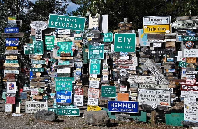
In 1942, a private in Company D, 341st Army Engineers added a sign on the existing directional post that pointed to his home town of Danville, Illinois. The tradition of leaving directional signs grew from that simple beginning.
My earliest recollection of this site when I passed by it in 1972 was of a modest row of signposts beside the highway. The Milepost magazine for that year did not even mention it as an attraction.
By 1992, 50 years after the first sign was placed, the number of signs displayed there had grown to 10,000. Today, that number is around 75,000, and the signpost forest is the biggest visitor attraction in Watson Lake.
Michael Gates is a Yukon historian and sometimes adventurer based in Whitehorse. His new book, D alton’s Gold Rush Trail, is now available in stores. You can contact him at msgates@northwestel.net