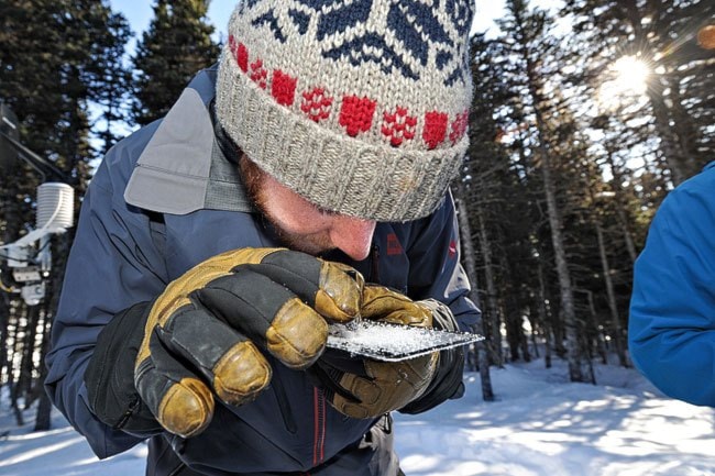
Matt Holmes can spot the seeds of an avalanche in a handful of snow.
On a roped-off plot of snow in the trees below Fraser Peak, he pulls a small screen marked with a tight grid pattern out of his tool kit, and scatters a handful of snow across it. Then, peering through a loupe - a magnifying glass roughly the size and shape of a shot glass - he is able to get an up-close, three-dimensional look at the size and shape of the area’s snow crystals.
The formation of the crystals drives snowpack stability: large, irregular, loosely packed snow crystals mean a weak snowpack, while smaller, more densely packed crystals create stability. The crystals are a key indicator of avalanche potential.
“If you didn’t put your hands in the snow every day,” says Holmes, “you’d be so out of touch with how things are developing.”
Holmes is one of three members of the Yukon Avalanche Association’s field team. Together, the team provides the first-ever public avalanche forecast in the Canadian North.
From the beginning of January until the end of April, and even into May, they’re out in the mountains between Whitehorse and Skagway almost daily, monitoring conditions and digging in the snow. Their program, launched in late 2011, is unique in North America.
Across the continent’s mountain regions, avalanche forecasters combine weather data with information about existing snow structures to build guidelines for the public about the likelihood of avalanches and their potential severity. In most areas, their data is provided by existing weather services, and by an array of private companies with an interest in avalanche safety: heli- and cat-skiing operations, ski resorts, snowmobile tour operators, and more. In a heavily used and populated area, the operators pool their data and a desk-based forecasting team takes it from there.
But in the Yukon, there is no existing data. With only a handful of residents scattered from Carcross to Skagway, and one road, the South Klondike Highway, winding through, the White Pass is a true wilderness - you won’t hear a weather forecast for Fraser on the radio during your morning commute. So the YAA field techs have the rare triple challenge of gathering their own data, analyzing it to produce a forecast, and then getting the word out to the public about their findings.
“The big difference up here, it’s a data-sparse region,” says James Minifie, a second avalanche technician on the crew. “We basically provide all the data.”
Minifie, Holmes, and avalanche forecaster Justin Abbiss make up the field team. They work out of a base at Fraser, in rotating teams of two. Once a month, they’re also joined by a more experienced avalanche forecaster from the Canadian Avalanche Centre in Revelstoke, B.C. The national centre collaborates with the Yukon’s program, and in late March the mentor they sent up was Joe Lammers, a senior forecaster who has a gift for metaphor when he explains how avalanches form and function.
There are two types of avalanches: “sluff” avalanches, which refers to a cascade of loose snow, and “slab” avalanches, in which a more cohesive swath of the snowpack breaks loose and slides downhill. Sluff avalanches can be dangerous under the right circumstances, but slab avalanches are a more consistent source of concern.
Slab avalanches form as a result of layering in the snowpack, and this winter’s weather has created a prime example.
There are three ingredients for the formation of a slab avalanche: a hard bed surface, a weak layer overtop, and then a final, overlaying slab of snow. This year, the Yukon’s February thaw created a hard rain crust on the early-season snow. That was eventually covered by a layer of large snow crystals called facets, similar to a frozen layer of dew. And the facets, in turn, were later covered by a subsequent snowfall.
Lammers likens the situation to placing a group of champagne glasses - the facets - on a hardwood floor, and then laying a mattress over top of the glasses.
Now imagine that the hardwood floor is angled to form a 30- or 45-degree slope. It wouldn’t take much to shatter the glasses and send the mattress crashing downhill - a slab avalanche.
The crew has a variety of tools at their disposal to help assess the extent of the avalanche hazard. The Yukon Avalanche Association has installed three weather stations in their forecast area: one at Fraser, one at Summit Knoll deeper into the White Pass, and one on Mount Anderson in the Wheaton Valley. Each solar-powered unit measures wind, humidity, and barometric pressure. At each station, the team also takes measurements on the most recent snowfall.
They also dig pits known as snow profiles, which allow them to see a cross-section of the layers in the snowpack and to test the layers’ susceptibility to collapse. And they spend a fair amount of their time just covering ground on their snowmobiles or by ski and splitboard, getting to know the terrain - its higher and lower-risk slopes and features - and chatting with members of the public. When they’re not in the field, they’re back in their office at Fraser, working on getting the word out to Yukoners about their findings.
“One of the arts in public forecasting is taking all this data and packaging it in a meaningful way for users,” says Lammers. The crew’s primary method is the avalanche bulletin, which they issue three times a week via their website, yukonavalanche.ca.
Beyond the bulletin, they also maintain a tech blog, where they delve into the state of the snowpack in more detail. Finally, when necessary they also have the option to issue a special public avalanche warning, as they did on the second-last weekend of March.
Those warnings aren’t necessarily issued when the risk of avalanches is at its highest. Rather, they tend to go out when the risk is considerable, but not extreme - a time when users may let their guard down. Factors that draw an unusually large crowd, like a holiday weekend, or sunny weather after a long ugly stretch, can also be at play.
James Minifie points out that the team cannot actually predict avalanches in the way that one might predict a thunderstorm. All they can do is assess the snowpack for its avalanche potential. It’s up to skiers and snowmobilers to make the right decisions to avoid triggering a slide. “We’re giving people tools,” he says.
The team urges the Yukon’s powder-lovers to acquire the knowledge and the gear required to survive in avalanche country. Read the bulletin, take an avalanche safety course, carry an avalanche beacon and probe - and know how to use them. Most people don’t have much understanding of how snow works - and that ignorance can be fatal. Says Lammers: “They know that it’s cold, it’s white, and it’s awesome.”