There’s a little island off the coast of Tuktoyaktuk, Northwest Territories that might be gone a few decades from now.
At its narrowest point, the long, skinny island is less then 40 metres wide, and it’s losing coastline at a rate of more than two metres a year. If that continues, it could be breached in 20 years.
“There’s a huge concern in Tuktoyaktuk to protect the island,” said Dustin Whalen, a physical scientist with Natural Resources Canada. That’s because the island lies just across from Tuktoyaktuk’s harbour, and forms a barrier that protects the harbour from the battering Beaufort Sea waves.
Once the island is breached, the harbour itself could be jeopardized by rapid erosion.
Coastal erosion isn’t just a concern in Tuktoyaktuk. Across the North, coastlines are retreating rapidly, likely thanks to a combination of melting sea ice and thawing permafrost.
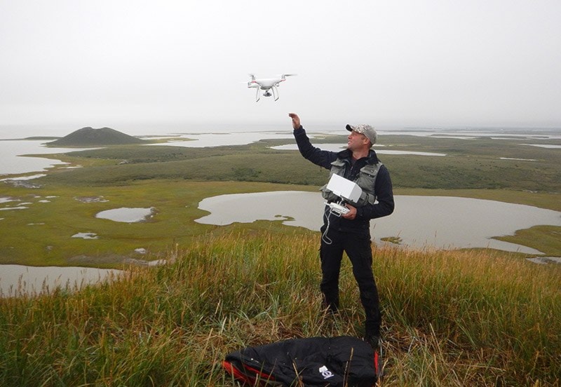
Researchers have been documenting the changing Arctic coastline for years. But now, for the first time, Whalen and his colleagues are using an aerial drone to gather more detailed images of the disappearing coast.
“When this drone technology came about… it just sort of absolutely made sense to use it up north,” Whalen said.
There’s nothing special about the drone that Whalen is using. It’s a Phantom 4, which sells for about $1,500.
“You can buy it at Best Buy,” he said.
The drone flies about 40 or 50 metres above the ground, and takes three or four high-resolution photos every second. By combining the photos together, researchers can build 3D images of the coast.
That’s a far cry from how this type of science used to work.
Before drones were widely available, researchers used to hire planes to take aerial photos, or they’d pay for satellite imagery. But the resolution was much worse, and the cost was vastly higher.
“For $1,500, we’re gaining something that 12 years ago would have been 10 times the cost, if not 20 times the cost,” Whalen said.
Researchers also used to map the coastline by physically walking along it with a GPS. But as it erodes, large sections of land begin to slump, creating a kind of quicksand that’s dangerous to walk in. “You can’t stand in it because you’ll sink right to the bottom,” said Whalen.
Now, the drone can take detailed photos of the areas that people can no longer get to.
The goal of this research, Whalen said, is to calculate how much sediment is eroding from the coastline into the Beaufort Sea year after year. That’s important, because more sediment in the water can change the conditions for marine life.
“If we can get a handle on how much more sediment is being deposited, then we’re able to assess this as an indicator of change due to climate,” Whalen said.
And right now, the numbers don’t look good.
Whalen said about 80 per cent of the Beaufort Sea coastline is eroding, and in some regions, up to 20 metres are being lost each year. Those rates have doubled since 2000.
Faster erosion is partly linked to a decline in sea ice, Whalen said. As more of the Beaufort Sea remains unfrozen for longer each year, heavy waves and storms have more time to chip away at the coastline.
The “double whammy,” he said, is that Arctic air is warming, and the permafrost that underlies much of the Beaufort Sea coastline is melting. As the ground thaws, it washes away much more easily.
“The coast is not only being hit by more storms, it’s also being hit by warmer air temperatures.”
Coastal erosion in the Arctic isn’t a new phenomenon. Several historic buildings on Yukon’s Herschel Island were moved inland more than a decade ago to protect them from the crumbling coast.
But Whalen hopes the drone will provide more precise information about how the environment is changing, and how Arctic communities can adapt.
Last summer, the drone took 70,000 photos of the coastline in the Northwest Territories, which are still being processed.
It wasn’t all smooth sailing, however. The drone doesn’t like to work in bad weather, as the researchers discovered when they tried to send it out during a rainstorm.
“We launched it and it came back right away and said it was getting wet and it didn’t want to work anymore,” Whalen said.
And once, when they launched it into 50 kilometre-per-hour winds, the drone flipped over and started taking photos of the sky.
Battery power is also a bit of a problem. Right now, the drone can only work for about 20 minutes before the battery runs out. As a result, the researchers have only mapped about 40 kilometres of the 800-kilometre Beaufort Sea coastline.
“This summer, we selected sites all in the NWT where we knew we had massive erosion,” Whalen said. The researchers consulted with Inuvialuit elders to find the areas that are changing fastest.
But in the future, he hopes to cover a broader area, including the Yukon portion of the coastline.
He also wants to help coastal communities like Tuktoyaktuk adapt to coastline erosion by surveying the entire hamlet with a drone. He hopes community members will use that information to decide what type of shoreline protection they will need.
“I think what’s a great story about this is we’re using a very cheap, innovative technology to map one of the most affected coastlines in the world… in ways that we never were before.”
Contact Maura Forrest at maura.forrest@yukon-news.com